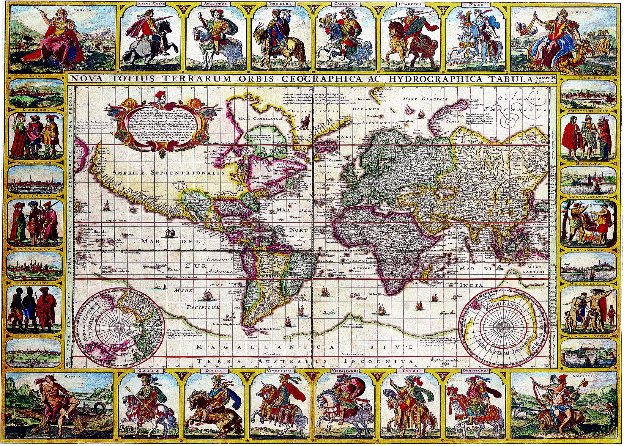
Claes Janszoon Visscher – Nova Totius Terrarum Orbis Geographica Ac Hydrographica Tabula Autore (1652)
Original price was: $9.99.$4.99Current price is: $4.99.
Claes Janszoon Visscher – Nova Totius Terrarum Orbis Geographica Ac Hydrographica Tabula Autore (1652)
Description
This work of art has been digitally enhanced without erasing signs of ageing for the sake of authenticity. Digital paintings are very popular right now as an affordable and stylish way to decorate and personalize your home and office.
Claes Janszoon Visscher – Nova Totius Terrarum Orbis Geographica Ac Hydrographica Tabula Autore (1652)
“Fine example of Claes Janszoon Visscher’s stunning and rare world map. Known as the Twelve Caesars Map, it is famous for the inclusion of the mounted Roman emperors in the decorative borders.
Visscher’s maps are known as some of the most spendidly ornate of the seventeenth century. This world map is one of four with embellished panels that Visscher issued between 1614 and 1652. The initial state of this planisphere was published in 1639, one year after Visscher made a double-hemisphere map of the world. Pieter Goos engraved the latter and Shirley surmises that he also likely engraved this piece. The present example is the fifth and final state, dated 1652.
The map, on a Mercator projection, includes a spectacularly broad North America. Greenland is seemingly attached to the continent, making an oceanic Northwest Passage seem unlikely. However, the presence of the Strait of Anian (see below) between Asia and North America suggests that a northeast or inland passage might still be possible, especially as a ship is suggestively placed near Nova Zem[b]la. A note in Greenland discusses the voyages of John Davis in the late sixteenth century, while an Indigenous man carries a canoe and a bow nearby.
Near to the Strait of Anian is Quivira Regnum. Quivira refers to the Seven Cities of Gold sought by the Spanish explorer Francisco Vasquez de Coronado in 1541. In 1539, Coronado wandered over what today is Arizona and New Mexico, eventually heading to what is now Kansas to find the supposedly rich city of Quivira. Although he never found the cities or the gold, the name stuck on maps of southwest North America, wandering from east to west.
In the Atlantic are the mythical islands of Frisland and Brasil. The tale of Frisland is told below. Hy Brasil is an enduring Atlantic chimera emerging from Celtic folklore. It ranges on maps from just off the west coast of Ireland to the area around the Azores. The island was initially described as a rich paradise not unlike Atlantis; it emerged from the depths for a short period and then would disappear. It started to appear on portolan charts in the fourteenth century and continued to be a stalwart of maps and charts into the nineteenth century. The island was the subject of a fanciful pamphlet by Richard Head in 1675. Despite no accurate reports of its whereabouts, the island appeared on Admiralty charts and other reputable maps for centuries, usually at a latitude of 51°N and at a longitude of 17°W.
A large cartouche fills the empty north of the Americas. However, it discusses not northern feats, but more southerly expeditions. The cartouche outlines the voyages of Christopher Columbus and Amerigo Vespucci in the Caribbean. It then turns to the pioneering circumnavigation of Ferdinand Magellan, or, rather, of his crew, as Magellan himself died in the Philippines. It also mentions the circumnavigations of Francis Drake (1577-1580) and Thomas Cavendish (1586-8). All three of these voyages went through the Strait of Magellan, as did Sebald de Weert at the turn of the seventeenth century and Spilbergen during his circumnavigation (1614-1617).
The final voyage mentioned in the cartouche is that of Le Maire, a reference to the circumnavigation of Jacob Le Maire and Willem Schouten (1615-1617). In an attempt to undermine the monopoly of the Dutch East India Company (VOC), Isaac Le Maire, Jacob’s father, planned an attempt to find another entrance to the Pacific from the Atlantic. Schouten and the younger Le Maire sailed in 1615. They sailed between Tierra del Fuego and an island they called Staten Land, entering the Pacific around Cape Horn and crossing the South Seas. This is the geography reflected on this map, with a pointed Tierra del Fuego flanked by the Strait of Magellan and the Strait of Le Maire and an open seaway around Cape Horn.
In the far south is a massive southern continent which encompasses Australia and has a northward thrust in the South Atlantic. The shore is incomplete south of Cape Horn. The toponym Beach is on a peninsula of this continent near Southeast Asia. This is a reference to a place mentioned in Marco Polo’s travels and frequently transposed to a southern continent in maps.
The map is full of many more fascinating details. The St. Lawrence River extends to the middle of North America. Patagonian giants are tucked into South America. Korea is shown as an island (see below) and the Great Wall is shown in the interior of China. In Africa, twin lakes are separated in the south by Mountains of the Moon. Ptolemy describes such a lakes-and-mountains layout in his works, although the precise identification of the Mountains of the Moon may have been a fourth century addition to his text. Early modern geographers took up the configuration in their maps. In the lower corners are polar inset maps.
The border of the map is filled with vignettes and imagery. In the corners are the Four Continents personified. Europe is surrounded by agricultural bounty, with a fierce infantry rifle barrage in the background. Asia is clothed in riches and seated on a camel while cavalry attack behind her. America, nearly naked, is on an armadillo, glancing back to a fight waged with spears. Africa, also without clothes, is on a crocodile with only animals and no violence behind her.
Between these women, on the left and right sides, are panels that show the typical dress of Europeans, Asians, Africans, South Americans, North Americas, and those of Magellanica, who are again giants. These are interspersed with views of ports: Baía de Todos os Santos, Pernambuco, Havana, Mexico City, Rome, Amsterdam, Jerusalem, and Tunis.
The most famous decorations are on the top and bottom borders. These are the dozen Roman emperors, seated majestically on their noble steads. Each ruler and horse are laden with the most elaborate suits of armor and regalia.”
After purchase you will have access to a PDF document with a link to these files available for download: 5×7”, 8×10”, 9×12”, 11×14”, 16×20″, 18×24″, 24×36″ and A1.
All files are in JPG format and at 300 PPI/DPI resolution. Please note that colours on your screen may be slightly different from the actual print.
This is not a physical item therefore nothing will be shipped to you.
You can download the PDF file at checkout after the payment clears.
Since these are printable downloads, refunds cannot be issued. Should you have any issues or questions please contact us and we will be happy to assist you.
For personal use only. Please do not use our digital art files for commercial use or resale.
© NovemaDigital
Only logged in customers who have purchased this product may leave a review.
Related products
-
Sale!

Otto Geigenberger – Spitz in der Wachau (1938)
Original price was: $9.99.$4.99Current price is: $4.99. -
Sale!
Gaines Ruger Donoho – Windflowers (1912)
Original price was: $9.99.$4.99Current price is: $4.99. -
Sale!
Nishikawa Sukenobu – Courtesan and Attendant Playing with a Dog (1700s)
Original price was: $9.99.$4.99Current price is: $4.99. -
Sale!
Vincent van Gogh – Fishing in Spring, The Pont de Clichy, Asnières (1887)
Original price was: $9.99.$4.99Current price is: $4.99.


Reviews
There are no reviews yet.