Petrus Plancius – Double Hemisphere World Map (1594)
Original price was: $9.99.$4.99Current price is: $4.99.
Petrus Plancius – Double Hemisphere World Map (1594)
Description
This work of art has been digitally enhanced without erasing signs of ageing for the sake of authenticity. Digital paintings are very popular right now as an affordable and stylish way to decorate and personalize your home and office.
Petrus Plancius – Double Hemisphere World Map (1594)
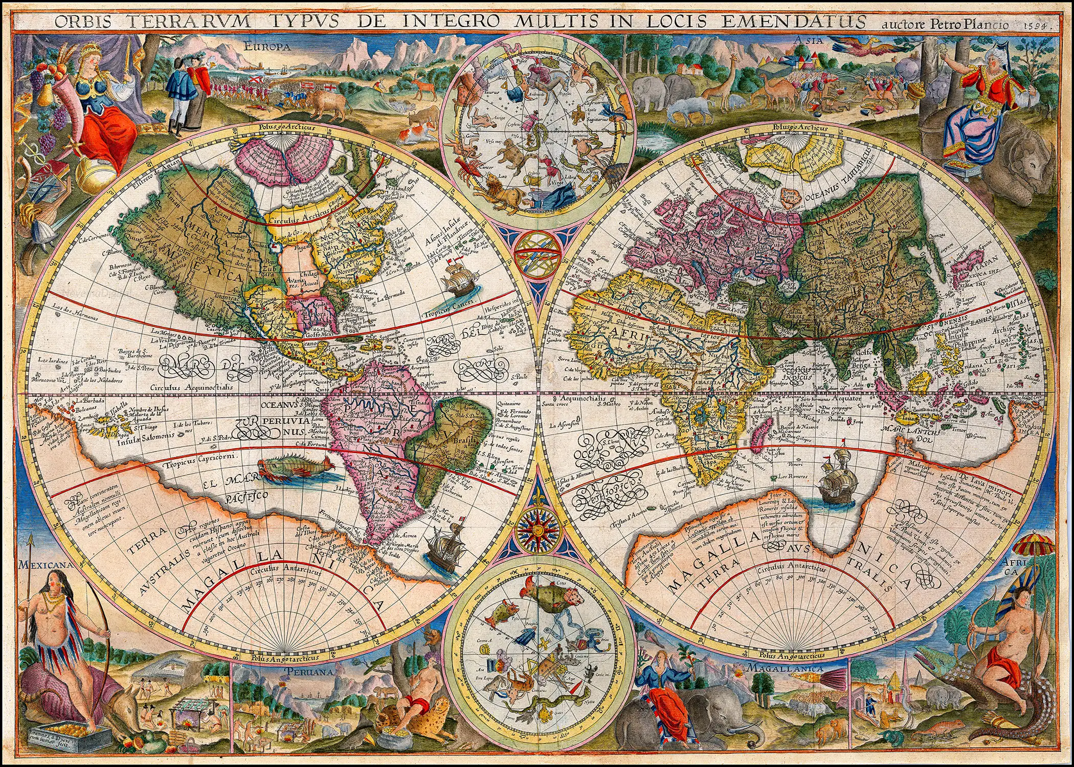
“This new world map by Petrus Plancius was first issued separately in 1595 or shortly thereafter and then later incorporated into editions of Linschoten’s Itinerarium from 1599 onwards. It has been engraved by Jan van Doetecum, a craftsman of great skill whose signature appears in the lower left-hand corner and who was associated with a number of Plancius’ maps.
The two main terrestial hemispheres are based on those in Plancius’ earlier world map of 1590, updated by geographical detail and with the addition of two celestial spheres from his large wall map two years later. The Far East, in particular, is more accurately represented. Korea appears as a peninsula for the first time and Plancius shows an improved outline for Japan, based on drawings by the Portuguese cartographer Luiz Teixeira. New Guinea, an island in the earlier maps, is however now joined to the extensive southern continent named Magellanica.
Inscriptions in the arctic show that Plancius was aware of reports of English voyages there and, perhaps to encourage forthcoming expeditions, Novaya Zemlaya is newly shown as an island. Koeman, writing in his introduction to Jodocus Hondius’ Wall-Map of Europe 1595 (Amsterdam, 1967) says of Plancius’ map that ‘Some copies show traces of the correction of an earlier edition in which the Arctic continent has been revised in order to depict the islands of Novaya Zemlaya’. I have not seen an unrevised state, and it is usually accepted that Barentsz.’ voyages of 1594 were first portrayed on the twin hemispheres which Hondius portrayed on his large map of Europe the following year, 1595.
The elaborate pictorial borders were inspired by drawings in the works of Theodore de Bry published a few years earlier and established a pattern of cartographical decoration that lasted over a century. The regions of the world are exemplified by means of symbolic female figures, by landscape vignettes, and by lively pictures of animals indigenous to each area. Doetecum has included elephants and camels, a giraffe, a unicorn, an ostrich and the footless bird of paradise; parrots, snakes and monkeys and – as unlikely beasts of transport for the regional figures – a rhinoceros, a crocodile and a giant armadillo. Europe and Asia are thus shown along the top of the map and Africa, Magellanica, Peru [South America] and Mexico [North America] along the bottom.
Plancius’ map had a widespread influence on other map-makers and it was issued unchanged throughout the various editions of Linschoten’s ‘Itinerarium’ from 1599 onwards. It is therefore occasionally available to collectors.”
After purchase you will have access to a PDF document with a link to these files available for download: 5×7”, 8×10”, 9×12”, 11×14”, 16×20″, 18×24″, 24×36″ and A1.
All files are in JPG format and at 300 PPI/DPI resolution. Please note that colours on your screen may be slightly different from the actual print.
This is not a physical item therefore nothing will be shipped to you.
Since these are printable downloads, refunds cannot be issued. Should you have any issues or questions please contact us and we will be happy to assist you.
For personal use only. Please do not use our digital art files for commercial use or resale.
© NovemaDigital
Only logged in customers who have purchased this product may leave a review.
Related products
-
Sale!

George Benjamin Luks – Winter, High Bridge Park (1913)
Original price was: $9.99.$4.99Current price is: $4.99. -
Sale!
Gustave Loiseau – House in Winter (1911)
Original price was: $9.99.$4.99Current price is: $4.99. -
Sale!

Jozef Israëls – Children of the Sea (1872)
Original price was: $9.99.$4.99Current price is: $4.99. -
Sale!
Stanisław Witkiewicz – Spring Landscape with a Pond (1902)
Original price was: $9.99.$4.99Current price is: $4.99.


Reviews
There are no reviews yet.